Bologna Maps - Maps Guide to Bologna

Bologna world-maps-guides.com - world maps guide with Bologna Maps - detailed regional, area and city maps of Bologna, Italy - Last updated 3/3/2016.

 Bologna Car Rental   Hotel Discounts   Flight Discounts


Maps of Bologna, Italy


A Quick Orientation of Bologna
The streets of Bologna are known for the 28 miles of arcades that line them. The arcades include a route out of the city, all the way to Basilica di San Luca, a distance of more than two miles. The centre of Bologna can easily be explored on foot and the city is enclosed by crumbling walls built in medieval times. For a good overview of the city, take a trip to the top of Due Torri at the base of via Rizzoli on Piazza di Porta Ravegnana, one of the city's best known landmarks.

The centre of the city is based around two piazzas, Piazza Maggiore and Piazza Nettuno. Piazza Maggiore is immediately recognisable thanks to the massive Gothic church of San Petronio, while at Piazza Nettuno you can see the Fountain of Neptune (Fontana di Nettuno).

Italy Map
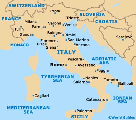
Map of Italy


Bologna Map

Map of Bologna


Useful Bologna Links
Guide to Bologna - detailed travel guide to Bologna, Italy
Bologna Guglielmo Marconi International Airport (BLQ) - Guide to Bologna (BLQ) Airport


BOLOGNA WORLD MAPS GUIDES...

Australia Guides

Austria Guides

Belgium Guides

Canada Guides

Channel Islands Guides

China Guides

Czech Republic Guides

Denmark Guides

Egypt Guides

England Guides

Estonia Guides

Finland Guides

France Guides

Germany Guides

Greece Guides

Hungary Guides

Iceland Guides

India Guides

Ireland Guides

Italy Guides

Japan Guides

Mexico Guides

Netherlands Guides

New Zealand Guides

Norway Guides

Poland Guides

Portugal Guides

Russia Guides

Scotland Guides

South Africa Guides

Spain Guides

Sweden Guides

Switzerland Guides

Thailand Guides

USA Guides

Wales Guides


Bologna Maps - World Maps Guide to Bologna

TravelSmart Ltd: Maps Guides - Copyright 2000-2015 - Bologna Maps - Maps Guide to Bologna