Auckland Maps - Maps Guide to Auckland

Auckland world-maps-guides.com - world maps guide with Auckland Maps - detailed regional, area and city maps of Auckland, New Zealand - Last updated 3/3/2016.

 Auckland Car Rental   Hotel Discounts   Flight Discounts


Maps of Auckland, New Zealand


A Quick Orientation of Auckland
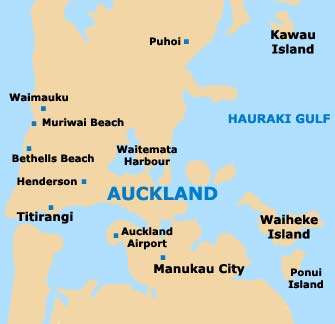
Auckland is located 186 miles from the North Island's most northern tip and rocky hills surround the city. To the east of the waterfront area is Queen Elizabeth II Square. From here, Auckland's main road of Queen street runs south and contains the Auckland Town Hall. At the southern end of Queen street you will find Karangahape Road, known by locals as K road.

The centre of Auckland lies between K road and the waterfront district. Ponsonby is a trendy area located to the northwest of the city centre, near Herne Bay. Parnell is a stylish area of bars, cafés and restaurants located southeast of Auckland's centre.
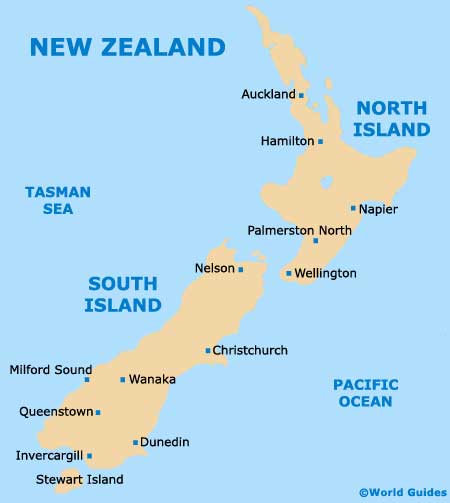
New Zealand Map

Map of New Zealand


Auckland Map

Map of Auckland


Useful Auckland Links
Guide to Auckland - detailed travel guide to Auckland, New Zealand
Auckland International Airport (AKL) - Guide to Auckland (AKL) Airport


AUCKLAND WORLD MAPS GUIDES...

Australia Guides

Austria Guides

Belgium Guides

Canada Guides

Channel Islands Guides

China Guides

Czech Republic Guides

Denmark Guides

Egypt Guides

England Guides

Estonia Guides

Finland Guides

France Guides

Germany Guides

Greece Guides

Hungary Guides

Iceland Guides

India Guides

Ireland Guides

Italy Guides

Japan Guides

Mexico Guides

Netherlands Guides

New Zealand Guides

Norway Guides

Poland Guides

Portugal Guides

Russia Guides

Scotland Guides

South Africa Guides

Spain Guides

Sweden Guides

Switzerland Guides

Thailand Guides

USA Guides

Wales Guides


Auckland Maps - World Maps Guide to Auckland

TravelSmart Ltd: Maps Guides - Copyright 2000-2015 - Auckland Maps - Maps Guide to Auckland